
The Boog pauses to survey the landscape from atop a massive rock outcropping
This hike marks the second time in a row I’ve found an incredibly interesting location almost by accident. This little jaunt to the coastal region surrounding Peggy’s Cove, NS proved to exceed my expectations in every way.
It all started on the afternoon of Sunday the 17th of July, 2011. I was restless because I hadn’t planned early enough for a Saturday hike (mostly because I had yet to find a new, worthy destination to go to) and I didn’t want the weekend to pass by without doing something outdoors. The problem was I needed to find a worthwhile destination close to my home base because I was running out of time. There are great hiking destinations very close to where I live: Crowbar Lake near Lake Echo and the Musquodoboit Harbour Trail System are both outstanding, but I had visited these places so often already. I needed to find someplace new.
I optimistically browsed my favorite site trailpeak.com to see whether or not any new entries had been added or if there was one I had missed that was close enough to where I live to make a quick trip in the time I had left that day. I found none. But then I remembered a post I had read last year when I was in a similar predicament: Polly’s Cove. I had passed this one over for some (what I realize now) very bad reasons: 1) it was rated 4/5 stars, not 5/5 (I have high standards, what can I say?), 2) its duration was only listed as 1 hour, 3) the OP had only put up one photo and 4) it was classified as “easy”. It all sounded like a walk in a park to me so I gave it no more thought at the time. This time however I was desperate for something, so I took a chance and realized how wrong I had been.

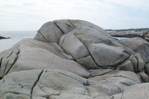
A Typical Vista in the Peggy's Cove Coastal Preservation Area
The Peggy’s Cove Preservation Area is a wonder to behold. Its uniqueness itself makes it a worthy hiking destination, even if the difficulty level is easy (for the most part – there are some areas that could be very dangerous if one isn’t careful). What makes it so unique is that the first couple of kilometers inland around this area is a sea of rock and low-growing brush – there are no big trees to block your view. It’s a coastal moor full of monolithic granite boulders and massive, exposed rock outcroppings, carved millennia ago by glacial activity. I’ve been an avid fan of Conan Doyle’s Sherlock Holmes stories since I was a teenager, and this place brought me right back to my imaginings of the English Moor on which the Holmes novel The Hound of the Baskervilles is set (though even more replete with rocks).

The ever attentive Boog looks out across the landscape not far from the trailhead
The trailhead I started from is located at N44°29.596′, W063°53.397′. It’s a small gravel parking area off the Prospect Road. I hiked south (roughly) from this position down the well trodden trail to a point where I followed a side trail to explore the western side of the area for starters. I was in awe of the rock formations and how unusual the landscape was to me. I came across a human made rock pile and even paused to film a brief self-portrait in context before I turned south again and followed the coastal slope down to Polly’s Cove proper. Here I found coastal rock formations very similar to that of Peggy’s Cove (only a couple of kilometers further down the coast, visible to the naked eye from where I was hiking).

The Majestic Blue Heron
I also was able to take some bona-fide wildlife photos when I spotted one of the most beautiful birds of the region – the Blue Heron – taking a moment to rest upon the rocky shore.

A small fishing vessel passes through the short channel between the short and Indian Island
Another interesting feature of my route was Indian Island. It sits majestically a short distance off the shoreline, with its distinctive weather-worn, smooth rock hillside and lush green northern hillside. After satisfying myself with several photos of the island and the cliff-side opposite along the shore I backtracked to the main trail and followed it a short distance to an intriguing, old foundation I can only surmise is an old World War II observation post (see gallery). By then time was running out for the day so I had to settle for what I had witnessed so far and returned to my car. I am planning a return trip, hopefully one week after this one to finish where I left off, and also to explore the vast expanse and higher hillsides along the opposite side (north of) Prospect Road.
I would highly recommend it as a great family hiking destination, even for small children. Only the coastal cliffs and a few of the bigger rock outcroppings pose any real falling hazard, and wildlife seems limited to smaller creatures wary of humans. Stick to the footpaths and everyone can have a safe and wondrous time.
The flora and fauna of this region is sensitive and delicate. If my post inspires you to visit this great place for yourself I implore you to stick to the existing trails and to walking on the granite rocks, and to pack out whatever you bring with you. Please also respect the wildlife there and give them their space. My Blue Heron encounter was a positive experience because I got only as close as I needed to in order to grab some good photos and get out of there. I was very careful to secure the dog first and made sure Mr. Heron’s wild life stayed a happy one.


-

- The Boog pauses to survey the landscape from atop a massive rock outcropping
-

- A Typical Vista in the Peggy’s Cove Coastal Preservation Area


-

- A small fishing vessel passes through the short channel between the short and Indian Island


-

- The Majestic Blue Heron


-

- Indian Island


